Current Bull Shoals Lake Level – US Army Corps of Engineers

Click the thumbnail to view the video
Introduction to Bull Shoals Lake
Welcome to Bull Shoals Lake, a mesmerizing reservoir nestled in the heart of the Ozark Mountains.
Overview of Bull Shoals Lake:
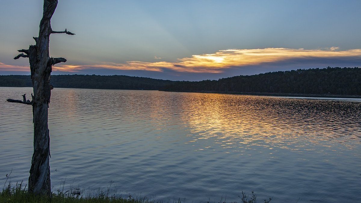
Stretching across the border of Arkansas and Missouri, Bull Shoals Lake is a vast man-made reservoir formed by the Bull Shoals Dam on the White River. With a surface area of approximately 45,000 acres and over 1,000 miles of pristine shoreline, it stands as one of the largest lakes in the Midwest United States.
Importance of Bull Shoals Lake:
- Flood Control and Hydroelectric Power: Bull Shoals Lake serves a crucial role in flood control, safeguarding downstream communities by regulating water levels during periods of heavy rainfall. Additionally, the hydroelectric power generated by the dam contributes to the region’s energy needs.
- Water Supply: The lake supplies clean, fresh water to the surrounding areas, ensuring a reliable water source for both residential and agricultural purposes. Its significance in sustaining the local ecosystem cannot be overstated.
- Tourism and Recreation: Bull Shoals Lake has gained widespread popularity as a premier destination for outdoor enthusiasts, attracting visitors from near and far. Its pristine waters, diverse wildlife, and picturesque landscapes provide an ideal backdrop for a plethora of recreational activities, making it a true paradise for adventure seekers.
The popularity of Bull Shoals Lake:
- Fishing Mecca: Renowned as an angler’s paradise, Bull Shoals Lake boasts exceptional fishing opportunities that lure avid fishermen from all corners of the country. The lake is teeming with a rich variety of fish species, including largemouth and smallmouth bass, crappie, catfish, walleye, and more. Its reputation as a trophy bass fishery has earned it a prominent position on every angler’s bucket list.
- Water Sports and Boating: Bull Shoals Lake offers a playground for water sports enthusiasts, with activities like boating, water skiing, tubing, and jet skiing captivating thrill-seekers of all ages. The expansive open waters, hidden coves, and secluded islands provide an endless canvas for unforgettable adventures.
- Camping and Hiking Haven: For those seeking a deeper immersion in nature, Bull Shoals Lake offers a myriad of camping grounds and hiking trails. Immerse yourself in the serene surroundings, awaken to the melodic calls of birds, and embark on scenic hikes that showcase the region’s breathtaking beauty.
Location and Geography of Bull Shoals Lake
Geographical Location:
- Bordering States: Bull Shoals Lake is situated in the heart of the United States, straddling the border between Arkansas and Missouri. Its expansive waters offer a tranquil escape from the bustling cities, immersing visitors in a serene and natural environment.
- Proximity to Surrounding Areas: Located within close proximity to charming towns and vibrant cities, Bull Shoals Lake provides easy access for travelers seeking a peaceful retreat or an exhilarating adventure. The lake’s shores are within reach of popular destinations such as Mountain Home and Branson, offering a diverse range of attractions and amenities.
Scenic Beauty and Topography:
- Vast Water Surface: Spanning across approximately 45,000 acres, Bull Shoals Lake enchants visitors with its vast expanse of crystal-clear waters. The lake’s shimmering surface reflects the surrounding rolling hills, creating a mesmerizing backdrop for leisurely boat rides, fishing expeditions, and water sports.
- Pristine Shoreline and Hidden Coves: Bull Shoals Lake boasts over 1,000 miles of pristine shoreline, punctuated by secluded coves and sandy beaches. These hidden gems provide tranquil spots for picnicking, swimming, and sunbathing, allowing visitors to unwind and bask in the lake’s natural splendor.
- Ozark Mountain Landscape: Nestled within the majestic Ozark Mountains, Bull Shoals Lake is surrounded by breathtaking scenery. Towering bluffs, lush forests, and verdant valleys characterize the region, captivating the senses and inspiring exploration. Hiking trails meander through the hills, rewarding adventurers with panoramic vistas and glimpses of the abundant wildlife.
Climate and Weather Patterns:
- Four Distinct Seasons: Bull Shoals Lake experiences a classic four-season climate, with mild springs, warm summers, colorful autumns, and crisp winters. Each season brings its own unique charm, allowing visitors to appreciate the lake’s beauty year-round.
- Outdoor Recreation Opportunities: The diverse weather patterns enable a wide range of outdoor activities throughout the year. From boating and swimming during the sunny summer months to fishing in the cool spring and fall seasons, Bull Shoals Lake offers something for everyone, no matter the time of year.
History of Bull Shoals Lake
From its humble beginnings as a visionary project to its transformation into a recreational haven, here are some of the remarkable events and milestones that have shaped the legacy of Bull Shoals Lake.
Construction and Purpose of Bull Shoals Lake:
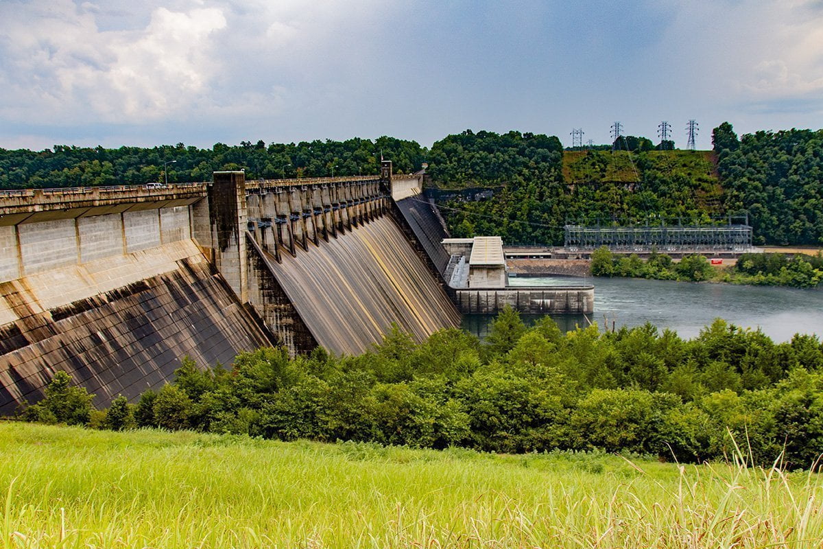
- Visionary Project: The construction of Bull Shoals Lake can be traced back to the mid-20th century when the U.S. Army Corps of Engineers embarked on an ambitious endeavor to harness the power of the White River and mitigate flooding in the region. The creation of the Bull Shoals Dam marked the genesis of this monumental project.
- Engineering Marvel: The construction of the dam commenced in 1947 and spanned several years. It required the relocation of families, businesses, and even cemeteries, as the rising waters would forever transform the landscape. The engineering prowess and perseverance of the workers resulted in the completion of the dam in 1951, culminating in the birth of Bull Shoals Lake.
Impact on the Local Communities:
- Economic Stimulus: The creation of Bull Shoals Lake brought about a significant economic boost to the surrounding communities. The influx of workers during the construction phase and the subsequent development of tourism-related industries provided new opportunities for local businesses, leading to a flourishing economy.
- Recreation and Tourism: Bull Shoals Lake quickly became a sought-after destination for outdoor enthusiasts, attracting visitors from far and wide. The pristine waters, picturesque landscapes, and abundant wildlife offered endless recreational possibilities, fostering the growth of tourism and the establishment of numerous recreational facilities, marinas, and resorts.
Significant Events and Milestones:
- Conservation and Preservation Efforts: Over the years, Bull Shoals Lake has witnessed dedicated efforts to conserve and protect its natural resources. Conservation programs have been implemented to maintain water quality, preserve wildlife habitats, and ensure sustainable fishing practices, safeguarding the lake’s ecological balance for future generations.
- Record-Breaking Fishing: Bull Shoals Lake has earned a well-deserved reputation as a fishing paradise, renowned for its trophy bass. It has served as the backdrop for numerous fishing tournaments, with anglers flocking to its waters in pursuit of record-breaking catches and unforgettable experiences.
- Historical Significance: Beyond its recreational allure, Bull Shoals Lake has played a role in preserving history. The lake’s creation led to the discovery and preservation of archaeological sites, including Native American artifacts and remnants of early settlements, providing valuable insights into the region’s rich cultural heritage.
Wildlife and Ecology of Bull Shoals Lake
One of the most remarkable aspects of Bull Shoals Lake is its thriving fish population. The lake is home to an abundance of game fish, including largemouth bass, smallmouth bass, spotted bass, crappie, and catfish. Anglers from far and wide flock to these waters in pursuit of their trophy catch. The lake’s crystal-clear waters create an ideal habitat for fish, with submerged structures, such as fallen trees and rock formations, providing shelter and breeding grounds. Remember, fishing regulations are in place to ensure the sustainability of the fishery, so be sure to familiarize yourself with local guidelines before casting your line.
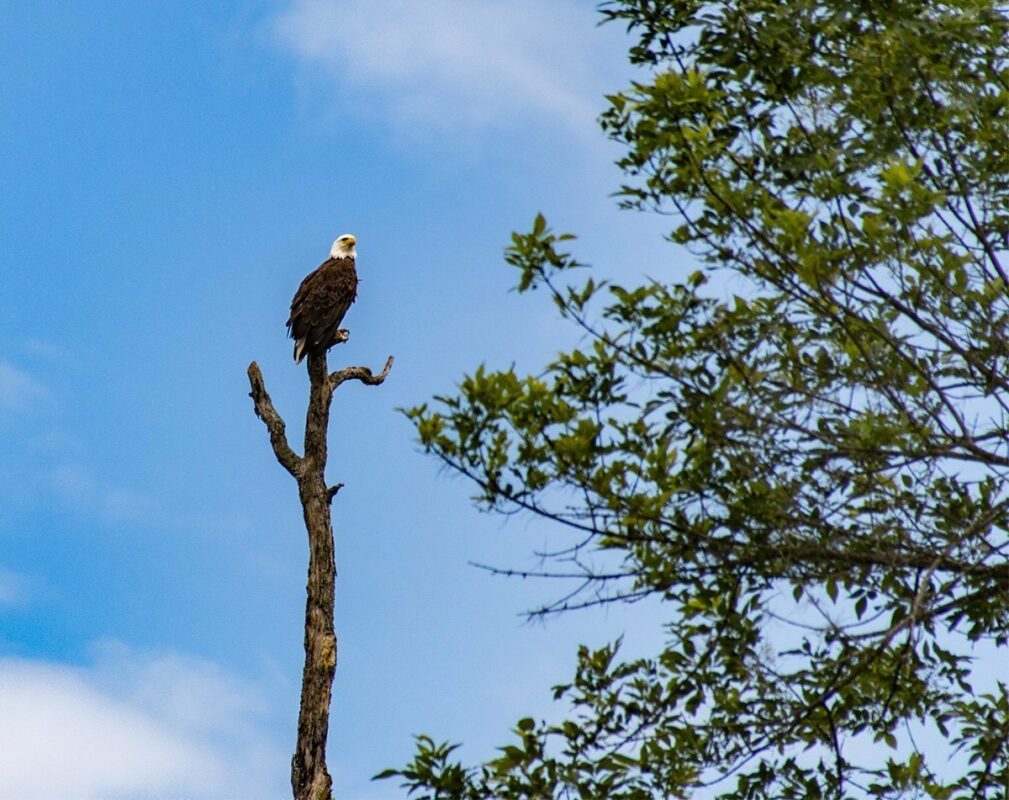
Above the surface, the shoreline and surrounding woodlands teem with a remarkable array of wildlife. The dense forests that hug the lake’s edge serve as a haven for numerous bird species, including bald eagles, ospreys, herons, and wood ducks. Their majestic flights and melodious calls add a touch of serenity to the already picturesque landscape. As you explore the lake’s coves and inlets, keep your binoculars handy to catch a glimpse of these magnificent creatures in their natural habitat.
If you’re a nature enthusiast, be prepared to encounter a variety of mammals during your visit to Bull Shoals Lake. White-tailed deer, foxes, raccoons, and squirrels are just a few examples of the wildlife that call this region home. Take a leisurely hike along one of the many trails that meander through the surrounding forests, and you may find yourself face-to-face with one of these fascinating creatures. Remember to observe wildlife from a safe distance and refrain from feeding or disturbing them to ensure their well-being.
Underneath the lake’s shimmering surface lies a hidden world brimming with aquatic life. Snorkeling or scuba diving in Bull Shoals Lake grants you a front-row seat to witness the vibrant underwater ecosystem. Explore the submerged rock formations and marvel at the schools of colorful fish gliding through the water. Crayfish, freshwater mussels, and various species of turtles are also commonly spotted in the lake’s depths. Admire the delicate balance that exists between these aquatic inhabitants and their environment, and remember to respect their homes by avoiding littering and practicing responsible water activities.
As you immerse yourself in the natural wonders of Bull Shoals Lake, remember that preservation and conservation are paramount. The delicate balance of this ecosystem relies on responsible human behavior. Treat the lake and its surrounding areas with care, leaving no trace behind. Follow guidelines for fishing and boating, and be mindful of the impact of your actions on the environment. By embracing a stewardship mindset, you can ensure that future generations will continue to marvel at the astonishing wildlife and vibrant ecology of Bull Shoals Lake.
Recreational Opportunities
Water sports enthusiasts will find themselves in paradise on Bull Shoals Lake. With its expansive size and crystal-clear waters, the lake is a haven for boating, water skiing, and jet skiing. Feel the burst of adrenaline as you zip across the shimmering surface, marveling at the stunning vistas that surround you. Kayaking and canoeing are also popular choices, allowing you to explore the lake’s hidden coves and picturesque inlets at your own pace. Remember to adhere to safety regulations, wear proper gear, and be mindful of other watercraft to ensure a thrilling and secure experience.
Fishing enthusiasts will be captivated by the abundant opportunities that Bull Shoals Lake offers. Reel in largemouth bass, smallmouth bass, spotted bass, crappie, and catfish, among other game fish species. Whether you’re a seasoned angler or a novice seeking to cast your first line, the lake’s diverse fish population provides an exciting challenge for all skill levels. Familiarize yourself with local fishing regulations, obtain the necessary permits, and consider hiring a knowledgeable guide to enhance your fishing experience. The perplexity of angling possibilities awaits you!
Hiking and nature enthusiasts will find solace in the breathtaking beauty that surrounds Bull Shoals Lake. Explore the numerous trails that wind through the lush forests and rolling hills, offering glimpses of the lake’s tranquil waters and panoramic vistas. Be prepared for bursts of wonder as you encounter diverse flora and fauna along your journey. Keep your senses alert for the calls of birds, the rustling of leaves, and the sight of elusive wildlife, such as white-tailed deer and foxes. Remember to pack essentials like sturdy footwear, water, and a map to fully immerse yourself in the natural splendor of the area.
Camping aficionados will find a plethora of options to pitch their tents or park their RVs around Bull Shoals Lake. Several campgrounds offer stunning lakeside views, allowing you to wake up to the soothing sounds of nature and embark on a day filled with outdoor adventures. Enjoy bursts of joy as you gather around a crackling campfire, sharing stories and roasting marshmallows under the starry night sky. Whether you prefer rustic campsites or sites with modern amenities, Bull Shoals Lake has perplexing camping options to cater to your preferences.
For those seeking a more relaxed experience, the lake’s shoreline provides opportunities for picnicking, sunbathing, and simply basking in the serenity of nature. Set up a picnic blanket under the shade of a towering tree, feel the bursts of warmth from the sun on your skin, and take in the panoramic views of the lake’s sparkling waters. Let the tranquility envelop you as you immerse yourself in a good book or engage in quiet contemplation.
As you indulge in the recreational opportunities that Bull Shoals Lake offers, it is crucial to respect and preserve the natural environment. Follow Leave No Trace principles, disposing of waste properly and leaving the area as pristine as you found it. Be mindful of any fire restrictions and fishing regulations to ensure the sustainability of the lake and its surroundings. By embracing responsible practices, you can help maintain the many recreational opportunities at Bull Shoals Lake for generations to come.
Flood Control
The chain of lakes of which Bull Shoals is a part are used as reservoirs to hold water that would otherwise cause increased flooding along the lower White and Arkansas Rivers as they flow toward the Mississippi River. You may remember the devastating flooding along the Arkansas River in late spring of 2019. This flooding would surely have been orders of magnitude worse if not for the work of the U.S. Army Corps of Engineers in holding large volumes of water in these lakes.
The normal level of Bull Shoals Lake is 659-660 feet above mean sea level. This is known as the power pool level. The lake level can fluctuate between 630 and 690 feet. The average depth of Bull Shoals Lake is 70 feet. Many places in the main channel reach over 100 feet deep, with a maximum depth of 210 feet.
More Details About Bull Shoals Lake
Bull Shoals Lake begins below the Ozark Beach Dam (also known as Powersite Dam) just outside Branson, MO. This portion of the White River system is the 22-mile-long Lake Taneycomo from below Table Rock Dam to the Ozark Beach Dam.
This dam is the only privately owned dam on the White River. The rest are managed by the U.S. Army Corps of Engineers. The Ozark Beach Hydroelectric Plant was completed in 1913. It is 1300 feet wide and has a spillway of 600 feet. The hydroelectric plant has 4 generators with a capacity of 16 megawatts.
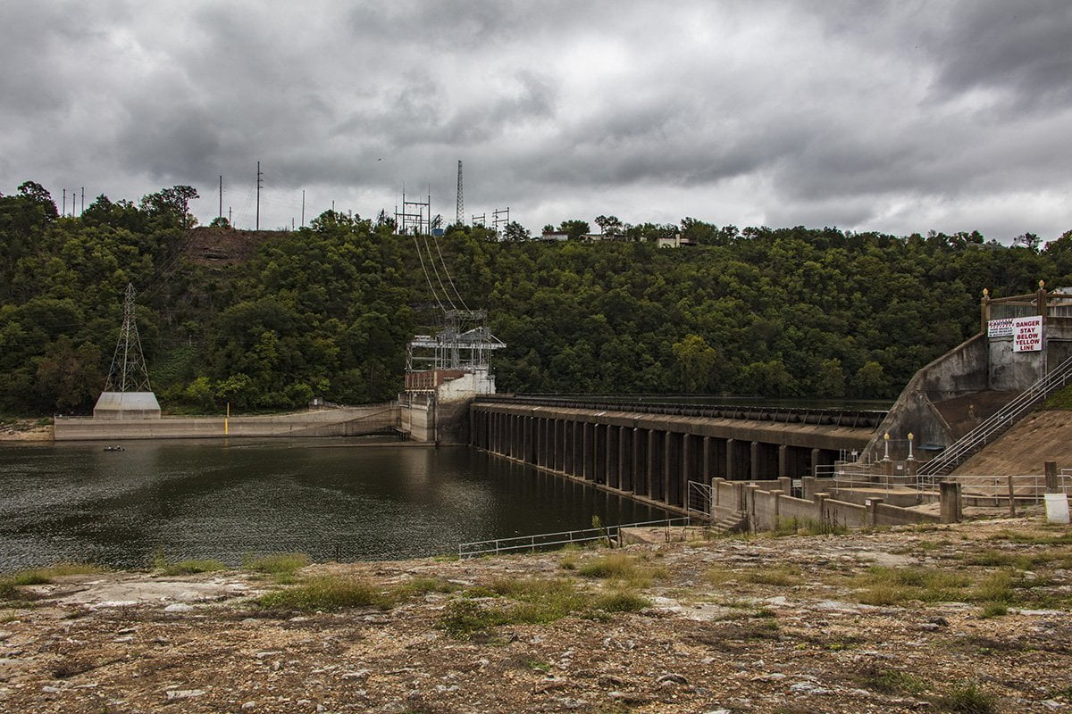
From this point, Bull Shoals Lake meanders east along the Arkansas/Missouri state line. The lake was formed when the White River was dammed by the construction of the Bull Shoals Dam. The Bull Shoals Dam was completed in 1951. At the time of completion, it was the fifth-largest dam in the world. The dam is 2,256 feet wide and is 256 feet tall. It has a total of 8 hydroelectric generators which can produce 380 megawatts of power at full capacity.
For outdoor enthusiasts, Bull Shoals Lake is an outdoor lover’s dream. The lake contains a surface area of 0ver 48,000 acres. Its miles of shoreline are undeveloped because the U.S. Army Corps of Engineers maintains a buffer zone along the shoreline. This has the consequence of also maintaining the scenic beauty of the lake.
There are numerous campgrounds, public boat ramps, marinas, and other outdoor opportunities. The lake is normally uncrowded even on holidays, which is another attraction of this scenic lake.
Fishing is excellent on the lake. Many species of sport fish abound in the deep clear waters. Bass, Crappie, Bluegill, Catfish, Walleye, and Striped Bass make their home here. Diving is also an activity that has a lot of participation due to the clarity of the waters.
Boating is pleasant on Bull Shoals Lake because it is normally much less crowded than comparable lakes in Arkansas and Missouri. We have been out with friends drifting on the lake on a party barge and may only see a handful of boats in several hours. The abundance of creek arms off the main lake means you can find a secluded spot and seldom be disturbed if that is what you prefer.
Another surprise you may not know regarding Bull Shoals Lake is that it has one of the few remaining ferry boats still in operation in the US. The Peel Ferry operates daily taking passengers and vehicles between the Arkansas and Missouri sides of Highway 125. For more info on the ferry, you can read my article at the link above.
Wildlife abounds in and around Bull Shoals Lake. During certain times of the year, you can see Bald Eagles fishing in the lake. Many other bird species call the lake home. Deer abound in the area, along with a number of other mammals, snakes, and amphibians. If you are a nature photographer you would do well to spend some time around the lake because there are plenty of creatures and scenic vistas for you to photograph.
If you would like to find out more about recreational opportunities on the lake you can visit the U.S. Army Corps of Engineers website or the Bull Shoals-White River area Chamber of Commerce.
You can also feel free to contact us using our contact form, and we’ll be happy to assist you with questions about the area, photo opportunities, etc. Also, be sure to follow and like our page on Facebook to see all the latest updates.