Welcome to the enchanting world of the Ozark National Forest in Arkansas! Known for its pristine wilderness, diverse ecosystems, and stunning natural beauty, this expansive forest is a haven for outdoor enthusiasts and nature lovers. In this exhilarating journey, we will unveil the hidden gems nestled within its lush embrace.
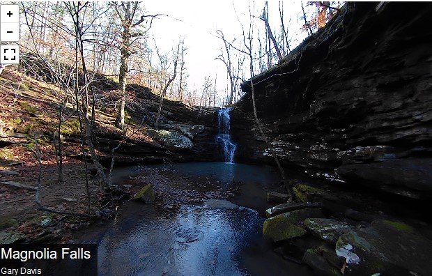
Our adventure begins with a focus on the captivating Magnolia Falls. This majestic waterfall, tucked away in the heart of the forest, is a sight that will leave you spellbound. With its impressive 26-foot drop, Magnolia Falls gracefully cascades over an array of rock formations, creating a picturesque scene that captures the essence of natural splendor.
As we delve deeper into the exploration, we will embark on an unforgettable hiking trail that leads us to this magnificent spectacle. The trail winds its way through the forest, offering a thrilling blend of panoramic vistas, serene creeks, and breathtaking encounters with wildlife. Each step is an opportunity to connect with nature and immerse ourselves in the wonder of our surroundings.
While our primary focus is Magnolia Falls, our journey will also introduce us to two additional hidden treasures: Woods Boys Falls and Hadlock Cascade. These secluded oases of tranquility offer their own unique charm and invite us to discover even more of the forest’s natural wonders.
Throughout our expedition, we’ll be treated to a myriad of sights and sounds that define the Ozark National Forest. The forest’s lush greenery, expansive hardwood trees, and vibrant wildflowers create a tapestry of colors and textures that change with the seasons. The melodies of native birds fill the air, and if we’re fortunate, we might catch a glimpse of a playful squirrel darting through the branches or a regal white-tailed deer gracefully navigating the forest.
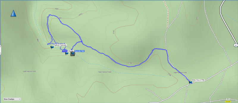
Magnolia Falls lies within the Ozark National Forest near Deer, AR. The trail to Magnolia Falls is a little over 2 miles in and out if you only want to visit these falls. There are two other falls you can visit in the same area easily. These falls are Woods Boys Falls and Hadlock Cascade. From the parking area on Newton County Road 6, the trail is on the right. There is a Wilderness Trail sign on the left side of the road. This is where you can park.
The Trail to Magnolia Falls
As you venture along the trail, be prepared to feast your eyes on breathtaking panoramic views of the forest. Take a moment to pause at the designated viewpoints and soak in the beauty of the surrounding landscapes. The Ozark National Forest is known for its diverse ecosystems, and the trail takes you through enchanting forests filled with towering hardwood trees. Keep an eye out for native birds, squirrels, and perhaps even catch a glimpse of a majestic white-tailed deer during your hike.
During your journey, you will encounter several creek crossings, adding an extra element of adventure to your hike. Take your time and tread carefully, as rocks in the creeks can be slippery. These crossings also provide a wonderful opportunity to cool off and refresh yourself in the clear, cool waters.
After a scenic trek through the forest, you will finally arrive at Magnolia Falls. As you approach the falls, the sound of rushing water grows louder, heightening your anticipation. Prepare to be mesmerized as you witness the magnificent cascade plunging into a crystal-clear pool below. Take a moment to feel the mist on your face and let the serenity of the surroundings wash over you. Don’t forget to capture this magical moment with your camera!
Magnolia Falls: A Majestic Wonder
Prepare to be amazed by the sheer beauty and grandeur of Magnolia Falls! This breathtaking waterfall is a true gem that showcases the power and elegance of nature. With a height of 26 feet, Magnolia Falls gracefully plunges down a series of rock formations, creating a mesmerizing spectacle that will leave you in awe.
What sets Magnolia Falls apart is its ability to captivate visitors throughout the year. In spring, the surrounding landscape transforms into a vibrant tapestry of colors as wildflowers burst into bloom. The cascading water against the backdrop of blooming flora creates a picturesque scene that is nothing short of magical. In summer, the falls offer a refreshing respite from the heat, inviting you to cool off in its crystal-clear pool. Fall brings a kaleidoscope of autumnal hues, painting the forest with rich shades of red, orange, and gold, making Magnolia Falls an even more captivating sight. Even in winter, when the forest is adorned with a frosty beauty, the falls retain their enchantment, creating a serene and ethereal atmosphere.
As you approach Magnolia Falls, the thunderous sound of rushing water grows louder, heightening your anticipation. The misty spray fills the air, refreshing your senses and immersing you in the energy of the falls. Take a moment to feel the cool mist on your face and let the awe-inspiring beauty of the surroundings wash over you.
Magnolia Falls also offers an incredible opportunity for photography enthusiasts to capture the essence of nature’s magnificence. The interplay of light, water, and rock formations creates a dynamic and ever-changing scene. Whether you’re aiming to capture the graceful flow of water or the delicate details of the surrounding flora, each photograph will reflect the unique character of Magnolia Falls.
When visiting the falls, be sure to exercise caution and respect for nature. The area around the falls can be slippery, so watch your step. Remember to leave no trace of your visit, preserving the beauty of the falls for future generations to enjoy.
Woods Boys Falls
To visit Woods Boys Falls head back to the main trail and then continue around the bluffs until you reach the bluff line on your left. Follow the trail here around the bluffs to Woods Boys Falls.
Woods Boys Falls may not be as grand in scale as Magnolia Falls, but its charm lies in its intimate and tranquil setting. The falls gracefully cascade down a height of 10 feet, creating a gentle and soothing atmosphere that invites you to sit back, relax, and become one with nature.
To reach Woods Boys Falls, you’ll venture along a lesser-known trail that meanders through the forest. The journey itself is a delightful experience, as you traverse paths lined with wildflowers and towering trees. The sounds of chirping birds and rustling leaves create a symphony of nature that accompanies you on your hike.
As you approach Woods Boys Falls, you’ll feel a sense of anticipation building. The gentle sound of cascading water grows louder, guiding you closer to the hidden oasis. The falls reveal themselves amidst a lush green backdrop, surrounded by moss-covered rocks and ferns that add to the serene ambiance.
Once you arrive, take a moment to truly appreciate the tranquility and beauty of Woods Boys Falls. Find a spot along the creek or on one of the nearby rocks and immerse yourself in the sights and sounds that surround you. Close your eyes and listen to the soothing melody of water as it flows over the rocks. Let the gentle mist kiss your skin, rejuvenating your spirit.
Photography enthusiasts will find plenty of inspiration at Woods Boys Falls as well. The intimate size of the falls allows for capturing intricate details and playing with different angles to showcase the interplay of light and water. Experiment with long exposures to create dreamy, silky effects or focus on capturing the delicate vegetation surrounding the falls.
Hadlock Cascade
Continue downstream and you will encounter Hadlock Cascade. The cascading water creates a symphony of soothing sounds, creating a tranquil atmosphere that invites you to pause and immerse yourself in its beauty.
As you approach Hadlock Cascade, you’ll be greeted by the sight of water gracefully flowing over textured rocks, surrounded by vibrant green vegetation. The cascade’s beauty is enhanced by the presence of mosses, which create a soft, velvety carpet along the rocks, adding an ethereal touch to the scene. Take your time to absorb the tranquil energy of Hadlock Cascade, allowing the serene atmosphere to rejuvenate your senses.
Hadlock Cascade offers a multitude of opportunities for photography enthusiasts to capture its natural allure. Experiment with different angles and compositions to showcase the cascading water, the lush green surroundings, and the delicate textures created by the moss-covered rocks. Long exposures can add a sense of motion and create a dreamy effect, while close-up shots can emphasize the intricate details of the cascading water.

The camera we use for 360° photos. Click the photo to get yours today!
360° Photo of Magnolia Falls. Use Your Mouse Or Move Your Phone To Look Around.
360° Photos of Woods Boys Falls. Use Your Mouse Or Move Your Phone To Look Around.
360° Photo of Hadlock Cascade. Use Your Mouse Or Move Your Phone To Look Around.
GPS Track
Download the Free GPS File
Elevation Data

On the map above click on “View Larger Map” to go to Google Maps. You can copy & paste the code below into Google Maps to view the location if needed. You can also use the code in Google Maps on your phone. Use the satellite view for the best overview.
Code
VJ77+2Q Deer, Arkansas