Some of our readers that have been following our adventures for a while may remember that in November of 2021, we tried to reach Punchbowl Falls, a.k.a. Dry Creek Falls, on a camping trip to the Richland Creek Wilderness area of the Ozark National Forest near Witt Springs, AR.
On that trip, we missed a key point and continued across the creek on the Ozark Highlands Trail. On this trip, we had done a little more research so we were pretty sure we knew where we went wrong on the last attempt.

The camera we use for 360° photos. Click the photo to get yours today!
The parking area for the trailhead is off Searcy Highway 12 if you are looking at Google Maps. The GPS coordinates are N35° 51.966′ W92° 55.424′. There is a large parking area, but on this trip, we had the trail to ourselves. If you are looking online for the trailhead you might also see it listed as Stackrock Trailhead.
As you begin the trail there is a sign and also a book for you to sign in with your name and where you are from. I thought this was a nice touch. As you begin the trail it slopes mildly downhill and soon you will pass the 151-mile marker for the Ozark Highlands Trail. The Ozark Highlands Trail is marked by white trail markers nailed to trees along the trail. If the marker is hanging straight up and down it indicates the trail continues straight. If it is hanging to one side or the other, that indicates the trail turns in the direction the marker indicates. This helps you to stay on the trail. Since we were here last the trail was worked on and some of the markers have been replaced, making it much easier to follow the trail.
Here is the track map from my GPS unit for the hike.
Download The GPS File
GPX files are also known as GPS Exchange files. These are text files that contain route data that you can download to your computer and then upload to your phone or handheld GPS unit. Donations help us to continue to bring you information about the Ozarks. No donation is required to download the file, but they are all greatly appreciated!
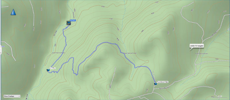
My GPS data show that the trip one way to the falls is 3.5 miles with an elevation change of around 700′. So the total trip is a little over 7 miles round trip.
The last time we came we continued on across the creek on the Ozark Highlands Trail and ended up above the falls with no way to get down, or even the chance to see the falls. This time we knew where we went wrong. If you don’t want to or are unable to download the .gpx file above the coordinates for the spot where you leave the trail are N35° 52.122′ W92° 56.653′. Turn right off the trail and follow an old road trace for about a half mile.
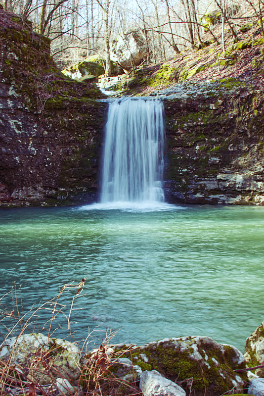
Be alert because someone has placed pink trial marker ribbons on the trees to help you find the break in the bluff line where you can climb down below the falls to see the incredible view of the green waters in the pool below the waterfall.
If you would like to view a video with much more of the Richland Creek area be sure and watch our video on YouTube. We also have a video with many more waterfalls you can see in the Ozarks.