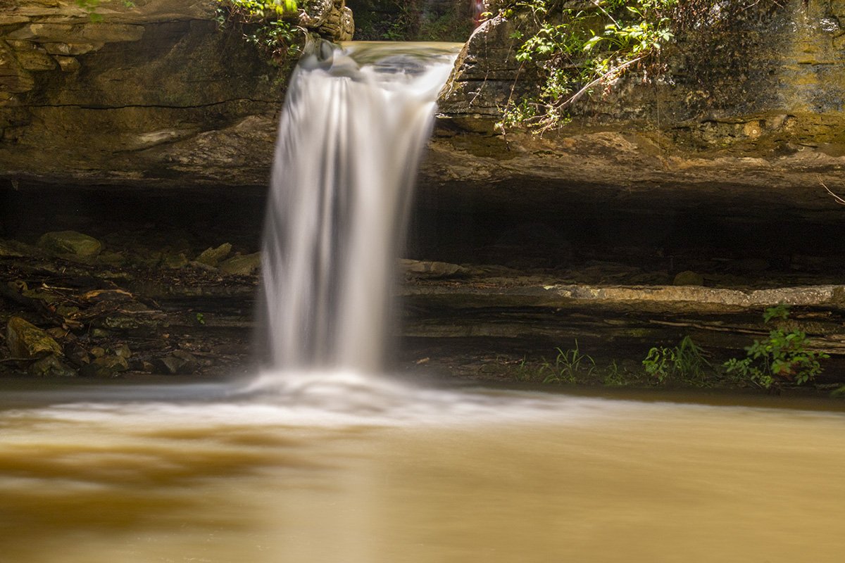
Paige Falls Trail is a heavily trafficked trail inside the boundaries of the Buffalo National River Park. Paige falls is a short but beautiful waterfall that appears to be spring-fed. It has water flowing even in drier times. If you have been a reader for any length of time on our blog it is no secret that I have an affinity for waterfalls. So when presented with the chance to visit two waterfalls in one trip I was ready to go. It seemed that after we got several inches of rain in the area would be a perfect time to head out to see Paige Falls and Broadwater Hollow Falls.
To reach these falls you will take Highway 43 out of Harrison. The road to reach the falls is marked and the sign will say NC2660. As you approach the town of Compton the road will be on your left. If you reach the city of Compton you have passed the road and will need to turn around and head back.
This is a county road but a word of caution is in order. The road is not paved and it is pretty rough. My 2 wheel drive SUV didn’t have any trouble but I would caution that it probably isn’t the best place to try and take that new sports car you just bought.
Follow the road for about 2 miles and you will see some places you can park. Walking a short way further along the road will take you around a sharp bend in the road to a low water crossing. This is the creek that runs down and creates both falls. The trail to the falls will be on your right just on the other side of the low-water crossing. There is also a nice cascade to your left as you cross the low water crossing.
The trail is short and it follows the creek bed which has been carved out of solid rock over the span of millennia. After crossing the creek there are several ways you can reach the falls. You can walk the rocks that line the creek, you can take the high trail which takes you along the creek, or there is a lower trail that takes you between two huge boulders. If you choose to take any other route than the high trail you will want to circle back to the high trail to get below the first waterfall you come to, which is Paige Falls. This route is easier than trying to climb down the rocks. The Paige Falls trail takes a short but fairly steep fork to climb down to the falls. There are many natural rock formations on the trail. You can walk between huge boulders and the kids will have a blast exploring all the hidden spots on the Paige Falls trail.
The creek shows how water erodes even bedrock with time. Once you have spent your time at Paige Falls it’s time to see Broadwater Hollow Falls. To reach Broadwater Hollow Falls you will need to climb back up to the high trail and follow it about 200 yards further downstream. The trail will lead down below the falls for a great view. The trail is a little steep and it was slick due to the rain the day we visited. Just be careful and wear good hiking shoes or boots and you should be just fine. Broadwater Hollow Falls is about 21 feet tall and is a cascading waterfall.
Broadwater Hollow Falls is a short distance further along the trail from Paige Falls. The trail is highly trafficked during warm weather. It continues past the falls and includes a spring flowing from a small hole in the rock below the falls. The landscape is breathtaking because of the huge rocks and boulders along the trail, which you can climb over or around to get better views of the falls.
In the summer, it is possible to walk among the boulders and follow the creek bed toward Cecil Creek. The day we visited, we had already hiked one waterfall early in the day. It was getting late when we started hiking the trail. We plan to get back soon and follow the trail through to Cecil Creek. There is also a sinkhole cave along the trail. It is currently closed to protect the bats which inhabit it. You can read more about Cecil Creek by following the link. We have a page dedicated to a hike we did along Cecil Creek to Thunder Canyon Falls.
This is a fun trip for the whole family. The hike is short so it isn’t too strenuous for the kids and the trail is not too bad for children either.

The camera we use for 360° photos. Click the photo to get yours today!
360° Photo. Use Your Mouse Or Move Your Phone To Look Around.
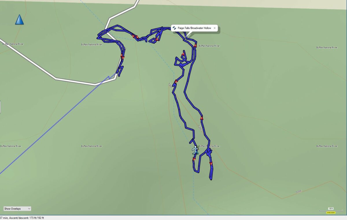
Download The GPS File
GPX files are also known as GPS Exchange files. These are text files that contain route data that you can download to your computer and then upload to your phone or handheld GPS unit.
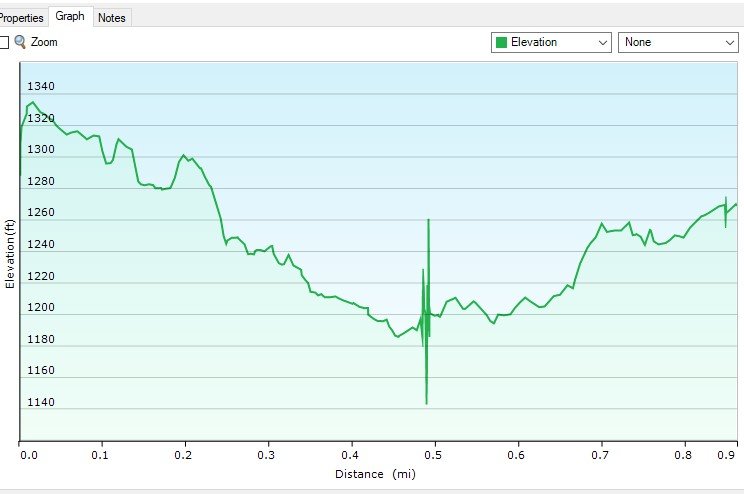
Elevation Data
On the map above click on “View Larger Map” to go to Google Maps. You can copy & paste the code below into Google Maps to view the location if needed. You can also use the code in Google Maps on your phone. Use the satellite view for the best overview.
Code
4P3M+X5 Harrison, Arkansas