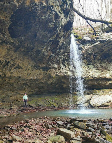
Dogwood Falls is a picturesque 36 foot waterfall in the Richland Creek Wilderness Area of the Ozark National Forest. This hike is not for the faint of heart. I have seen it described from easy to moderately challenging. Difficult would be a better description. But if you are willing to work for it, the payoff is well worth the effort. Watch the video below, or keep reading.
Parking for Dogwood Falls
There is not a designated parking spot for the hike to Dogwood Falls. The spot we parked is a short distance from the parking spot for the trail to Sandstone Castle. If you are familiar with this area continue up the road a short distance and pull to the side. Be sure and don’t block traffic when you park.
If you are coming in from the Lurton side when you get to Iceledo Gap drive approximately .4 miles on FR 1205. If you are coming in from the opposite direction drive approximately 1.1 miles from the junction of FR 1200 and FR 1205.
GPS Coordinates for parking: N 35.844018 W 92.983809
The Hike to Dogwood Falls
After parking cross to the north side of the road and head downhill. The hike to the falls is only around 0.4 miles, but the elevation change is around 500 feet. If you look at the contour lines on a map you will see how steep and rugged the hike down to the waterfall is. Making it even more of a challenge is the copious amount of briars everywhere after you get off the ridge line. This is not a hike you want to try in shorts. Unless, of course, you don’t mind cuts and scratches all over your legs!
We found a drainage off the ridge that provided a little better footing and we were able to zigzag down to the bottom using the rocks to help with traction. Any way you go down is a challenge, as you can see from the video I posted above.
The Waterfall
Once you reach the stream head downstream for a short distance and you will see a drop in the creek. This is the top of the waterfall. Be careful around the top of the falls. The rocks are smooth and slippery, and the rocks around the top are sandstone so they could give way if you aren’t cautious.
I saw it recommended to cross the creek and make your way down of the left side of the creek. We found a better way that is not so steep. Stay on the right side of the creek, (if looking downstream), and follow the bluff for a short distance. You will see a break in the bluff where you can scramble down.
We scrambled down all the way to the creek going down, then had to navigate large boulders and fallen logs. A better way is to stay along the bluff line and make your way down. It is not as steep and has better footing. We found this out once we were ready to make our way back up the bluff. At least the climb back out was not nearly as treacherous.
Once you have spent some time at the falls it’s time to head back out. This is the most challenging part of the hike. We worked our way back to the top by using the zigzag technique and not heading straight uphill. Remember, this is almost 500 feet back to the top, and much of it is very steep until you are almost back to the road.
If you want to attempt this hike to Dogwood Falls you can put the GPS coordinates in your GPS device and bushwhack down like we did. Alternatively, you can download the route to your phone from AllTrails.
If you decide to use the AllTrails map be sure and download the map for use offline. There is little, if any, cell reception in this area, especially once you leave the ridges. You won’t have reception to use the map online, so go ahead and download it before you go.
If you want to explore other hiking trails in the Ozarks be sure and check out my Hiking Blog for other trails and GPS coordinates/routes.